
17
Oct
Quantum Might Be The Solution to GPS Denial
By
Remo Marini
In September 2025, the aircraft carrying European Commission President Ursula von der Leyen suddenly lost its GPS navigation while approaching Plovdiv, Bulgaria – the result of suspected Russian jamming [1]. Air traffic controllers had to switch the flight to ground-based navigation systems to ensure a safe landing. This incident underscored the growing vulnerability of critical transportation to GPS denial tactics like jamming and spoofing. Such interference has surged amid geopolitical conflicts; for example, almost 50,000 GPS spoofing incidents were reported on aircraft in 2022 [2].
Military and civilian leaders worry that an adversary could interrupt navigation across an entire region by disrupting satellite signals. Indeed, analysts estimate a single day of GPS outage could cost over $1 billion in economic losses, and over 1,000 flights per day are already being disrupted by GPS jamming incidents [3]. As GPS jamming becomes a weapon of electronic warfare and even a tool for non-military sabotage, finding alternative navigation methods has become a national security priority.
One promising avenue is quantum sensing – using the extreme sensitivity of quantum physics to build navigation systems that do not rely on satellites at all. Quantum-based sensors can measure motion, rotation, magnetic fields, and time with unprecedented precision by exploiting phenomena like atomic superposition and entanglement [4]. Their inherently high sensitivity and stability make them ideal for detecting the smallest changes in a vehicle’s movement or environment. In the quest to navigate securely through a GPS-denied world, quantum sensing technologies are emerging as game-changers.
Quantum Inertial Navigation: Drift-Free Movement Tracking
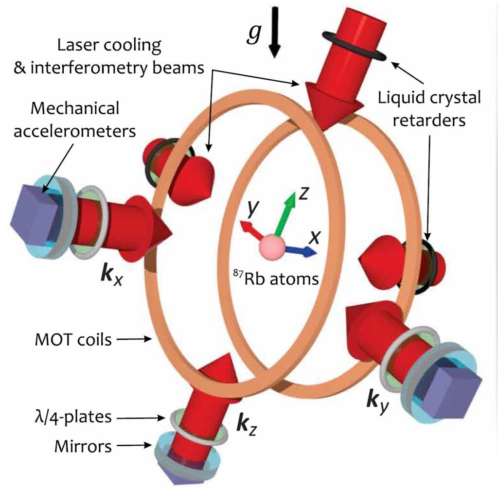
Design concept and geometry of a Quantum Inertial Navigation System. The acceleration components are measured along the wave vectors kx, ky, and kz, which are perpendicular to the surface of their respective mirrors. MOT, magneto-optical trap. From ScienceAdvances.
Traditional inertial navigation systems (INS) use accelerometers and gyroscopes to track a vehicle’s movement without external signals, but they inevitably drift over time as small measurement errors accumulate [5]. A classical INS can keep you on course for a short while, but eventually it needs a GPS fix to correct its growing positional error. Quantum inertial navigation tackles this problem by using atoms as the sensors instead of mechanical parts.
In a quantum inertial measurement unit, clouds of atoms are cooled to extremely low temperatures and manipulated with lasers in a technique called atom interferometry [5]. The atoms are placed into a quantum superposition, meaning each atom follows two paths at once, and then those paths are recombined. Any acceleration or rotation the system experiences will slightly alter the atoms’ wavelike interference pattern. By reading this pattern, the device can precisely determine how the sensor has moved in space. In essence, the atoms themselves act as ultra-sensitive gyroscopes and accelerometers.
Think of an atom interferometer as a “quantum stopwatch” for motion. When atoms are split into two paths by carefully timed laser pulses, each path accumulates a phase that depends on how the atom is moving. If the platform carrying the device accelerates or rotates, one path experiences a slightly different phase shift than the other. When the two paths are recombined, this phase difference shows up as a change in the atoms’ interference pattern (remember the wave-particle duality and the possibility to consider atom as waves). By measuring that shift with extreme precision, the device extracts the exact acceleration or rotation the atoms felt.
This process is similar to what was used to detect gravitational waves with LIGO. That experiment was also an interferometry that showed changes in the length of one of the two paths the light was taking.
Because all atoms of a given type are perfectly identical and free of mechanical drift, a quantum inertial sensor can measure motion with extraordinary consistency. Even over long periods, it exhibits negligible bias compared to conventional INS devices. Studies indicate that atom-based inertial navigation could be orders of magnitude more accurate, enabling high-precision dead reckoning for hours or even days without requiring GPS updates. In fact, aerospace engineers have already demonstrated a quantum inertial navigation system in flight.
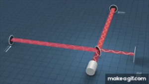
In 2024, Boeing and its partners flew a test aircraft for four hours using only a quantum IMU for guidance, ending the flight with a positioning error of only tens of meters (as opposed to many kilometers of drift with a regular INS) [6]. The quantum IMU – built with three atom-interferometer sensors to cover all axes – was able to operate successfully through takeoff, flight maneuvers, and landing while outputting real-time navigation data. The UK has likewise reported its first quantum-assisted navigation trials on both an aircraft and a naval vessel in 2024, proving that this technology works in real-world conditions.
Boeing on board the flight test. Navigating relying only on quantum sensors.
However, current quantum inertial setups remain bulky and complex. They typically involve vacuum chambers, ultra-cold cooling systems, and precision lasers – equipment that can fill a laboratory room. Ongoing engineering efforts are focused on miniaturizing and ruggedizing these cold-atom devices without sacrificing accuracy. Even as quantum IMUs shrink, satellite navigation won’t disappear – instead, quantum inertial units will likely serve as an augment or backup, kicking in when GPS is unavailable or untrustworthy. Quantum navigation is expected to find early adoption in niches where GNSS signals cannot reach or be trusted (for example, in submarines underwater, in deep space travel, or during military jamming scenarios) rather than as a full replacement for everyday GPS use.
Quantum Magnetometry and Magnetic-Field Mapping
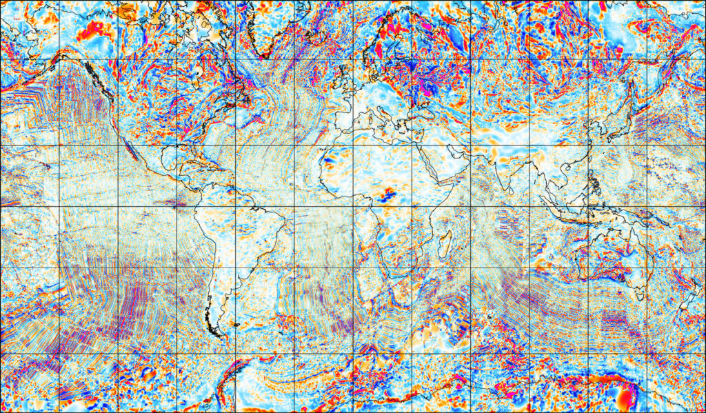
World Digital Magnetic Anomaly Map (WDMAM), this is used as a reference for magnetic field variation and sensing.
Another quantum approach to navigation turns the Earth itself into the guide. Magnetic anomaly navigation uses minute variations in Earth’s magnetic field as natural signposts. The planet’s crust and core create subtle local distortions in the geomagnetic field – essentially a fingerprint that can be mapped.
If a vehicle carries a highly sensitive quantum magnetometer, it can measure the surrounding magnetic field and compare it to a known global map, like the World Digital Magnetic Anomaly Map (WDMAM), pinpointing its location without GPS. This concept isn’t entirely new (submarines have long used magnetic maps to aid navigation), but quantum technology is dramatically improving its viability.
Quantum magnetometers, such as those based on atomic vapor cells or nitrogen-vacancy diamonds, can detect magnetic fields with phenomenal precision – down to levels a billion times weaker than Earth’s ambient field [8]. And importantly, magnetometry navigation is passive: unlike GPS or radio beacons, there is no external signal for an enemy to jam or spoof.
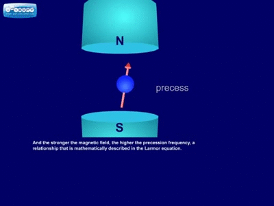
A quantum magnetometer works by watching how atomic spins respond to magnetic fields. Inside the sensor, atoms such as rubidium are held in a vapor cell and illuminated with laser light. When a magnetic field is present, the spins of these atoms precess — they wobble like tiny quantum gyroscopes. The rate of this wobble depends directly on the strength and direction of the magnetic field. By monitoring how the atoms absorb or emit light as they precess, the device extracts an exquisitely precise measurement of the local magnetic field.
Because Earth’s crust contains iron-rich minerals, its magnetic field has small, stable variations — “anomalies” that are unique to specific regions. With a quantum magnetometer sensitive enough to pick up changes of just a few nanotesla, a vehicle can continuously compare its readings to digital magnetic anomaly maps. The result is a passive, unjammable navigation fix tied to the planet itself — effectively using Earth’s geology as a natural GPS.
In 2024, Boeing provided a compelling real-world demo of quantum magnetic navigation. As part of its GPS-free flight trials, Boeing tested a system called AQNav (developed by SandboxAQ) that uses an advanced quantum magnetometer to continually correct the aircraft’s route. The onboard sensor measured the ambient magnetic field, and software correlated it with a preloaded reference map – effectively “anchoring” the inertial navigation solution and preventing it from drifting over time. In Boeing’s tests, the quantum-enhanced navigation system kept the plane’s calculated position within tight bounds, significantly curbing error growth over the course of the flight.
Even more impressively, quantum magnetic sensing has now achieved what researchers call a “quantum advantage” in navigation. In April 2025, Australia’s Q-CTRL announced the first commercial quantum advantage in GPS-free navigation: its quantum-enhanced system was tested in both airborne and ground vehicles and consistently outperformed a high-end conventional inertial navigation unit by up to 50× in accuracy [3]. Q-CTRL’s method works by detecting tiny, otherwise imperceptible geophysical signals – essentially magnetic or gravitational anomalies – that serve as fixed landmarks for the vehicle’s quantum sensors. By locking onto these natural reference points in the Earth, the quantum system can maintain an accurate fix of its position even with zero input from satellites. The achievement of a 50-fold improvement over the best classical device was a major milestone, proving that quantum sensors can deliver true strategic gains in navigation.
Furthermore, U.S. DARPA selected Q-CTRL for a major project to develop next-generation quantum navigation systems for advanced defense platforms by awarding the company with 24.4 million $ [10].
Securing Navigation: Europe’s Search for Alternatives
Europe remains heavily reliant on GPS, which is controlled by the United States. To reduce this strategic dependency, the European Union deployed its own satellite network, Galileo, providing independent GNSS coverage. Galileo offers high-precision positioning services, but like GPS it relies on faint signals from orbit and is just as vulnerable to interference. Recent events have made clear that even a sovereign European GNSS cannot fully safeguard navigation if adversaries target the space infrastructure. Accordingly, European defense and transportation authorities are exploring a range of complementary solutions beyond satellites.
The push for GPS alternatives has gained urgency as jamming incidents grow more frequent. NATO officials have called Russia’s ongoing GPS interference campaign “staggeringly reckless,” warning that the threat to Europe’s aviation and infrastructure is acute [9]. As cutting-edge trials continue to accumulate successes across inertial, magnetic, and other modalities, Europe and its allies are laying the groundwork for navigation that remains secure even under GPS denial. In the coming years, quantum-enhanced navigation may evolve from experimental to essential, ensuring that planes, ships, and vehicles can find their way even when conventional satellites go dark.
References:
- Reuters, “EU says von der Leyen’s plane GPS system was jammed, Russian interference suspected”, Sept 1, 2025 reuters.com
- Madeleine North, “What is quantum navigation – and could it replace GPS?”, World Economic Forum, Jul 5, 2024 weforum.org.
- Q-CTRL (via The Quantum Insider), “Q-CTRL overcomes GPS-denial with quantum sensing, reports quantum advantage”, Apr 14, 2025 thequantuminsider.com.
- Quantum Zeitgeist, “What is Quantum Sensing?”, June 15, 2024 quantumzeitgeist.com.
- Samuel Lellouch, “Quantum alternative to GPS navigation will be tested on US military spaceplane”, The Conversation, Aug 14, 2025 techxplore.com.
- Mychaela Kekeris, “Team completes 1st quantum navigation flight test”, Boeing Innovation Quarterly, Mar 11, 2025 boeing.com.
- Bernice Chan, “No GPS, no problem: Researchers are making quantum sensing tools more compact and accurate to replace GPS”, Phys.org (USC Viterbi School of Engineering), Jul 9, 2024 phys.org.
- Defence Industry Europe, “Leidos develops quantum-based navigation to counter GPS jamming”, Jun 7, 2025 defence-industry.eu.
- Lorenzo Tondo, “Italy considers hiding state flight paths after jamming of von der Leyen plane”, The Guardian, Sep 2, 2025 theguardian.com.
- Q-CTRL, “DARPA Selects Q-CTRL to Develop Next-Generation Quantum Sensors for Navigation on Advanced Defense Platforms”, Press Release, Aug 27, 2025 q-ctrl.com.
RELATED
Posts

28
May
The paradox of Intellectual Property in Deep tech
Can commercial advantage and scientific research coexist?
In late January 1987, a small group of physicists knew something the rest of the world did not. They had found a ceramic material that became superconducting at 93 kelvin, a temperature high enough...

9
Jan
How to Build, Measure & Control a Superconducting Qubit
Quantum sensing has shown promising results in GPS-free navigation

27
Sep
Quantum Computing and Environmental Sustainability
Quantum computing may look energy-hungry, yet its speed, chemistry breakthroughs, and reversible logic hint at a future of truly sustainable computing.

15
May
Qubits technologies
The competing technologies in the run for a Fault-Tolerant Quantum Computer

27
Feb
Microsoft Unveils Majorana 1: The First Quantum Processor with Topological Qubits
Discover Majorana 1, Microsoft's first quantum processor based on topological qubits. A breakthrough in quantum computing with the potential to solve large-scale industrial problems sooner than expected.